Maps Are Like a Gateway Drug
BLUF
Challenging the rules-based international order is a key feature of strategic competition. PRC’s new map shows an example of Chairman Xi’s efforts to define the world to his advantage, despite international norms. The map’s significance lies in the leader’s mindset, not the unoriginal claims. Like “build it and they will come,” publishing contentious maps raises geopolitical tensions throughout the western Pacific. If affronted countries move beyond diplomatic responses, economic disruptions could be one of the unintended consequences.
Why does this matter?
Energy leaders should use this event as a thought experiment to consider how their business would respond if an autocratic dictator encroached on their business operations. Chairman Xi’s approach to defining his own reality presents geopolitical risk to companies operating in PRC’s sphere of influence. The blatant encroachment of PRC upon other nations’ sovereign territory while drawing their borders should be a concern for everyone.
This post does not delve into the history and geography of each territorial dispute. It is about the mindset behind those who would publish such a map.
Key Take-Aways
- PRC’s map expands its territory in three cardinal directions.
- Maps Matter – They can be a “gateway drug” towards conflict.
- Disruption of global shipping through the South China Sea would affect business in all industries.
Disclaimers: The views expressed in this article are those of the author and do not reflect the official policy or position of the Department of Defense or the U.S. Government. The appearance of external hyperlinks does not constitute endorsement by the United States Department of Defense (DoD) of the linked websites. The DoD does not exercise any editorial, security or other control over the information you may find at these locations.
PRC’s map expands its territory in three cardinal directions.
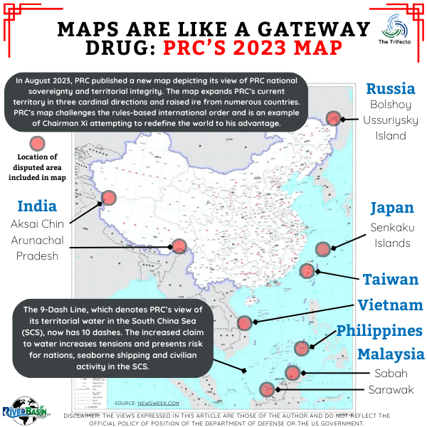
Despite the territorial disputes not being new, let’s briefly reiterate each claim. Overall, the most significant encroachment is in the South China Sea (SCS). Since 1952, the PRC identified its claimed territory in the SCS with the 9-Dash Line. (For those unfamiliar, the 9-Dash line is an imaginary line in the water of the South China Sea that literally comprises nine dashes on a map. The simplicity can be confusing.) The 2023 map features an expanded line with 10 dashes, covering a greater territory.
The issue with PRC’s claims in the SCS is that it violates other countries’ Economic Exclusion Zone (EEZ). A country’s EEZ generally extends 200 nautical miles from shore and was adopted through Article 82 of the United Nations Convention on the Law of the Sea (UNCLOS) in 1982. Countries have jurisdiction over living and non-living resources within their EEZ. Hence, conflicts can arise when two countries claim the same water. This ongoing issue remains a major source of disagreement among SCS bordering countries.
In response to the new map, the Malaysian Foreign Ministry released a statement saying their country is not bound to PRC’s 2023 map. Similarly, the Philippines lodged a diplomatic protest over the new PRC map, infringing on its sovereignty and territorial integrity.
Moving on to the land disputes…
Overall, PRC included disputed land within its territory according to the map. In Russia, this included a relatively small sedimentary island along the far northeastern Chinese border. At the confluence of the Ussuri and Amur rivers along the China-Russia border, there are several small islands. This area is in the farthest northeast section of China. Russians call the largest of the islands Bolshoi Ussuriysky Island, while PRC calls it Heixiazi Island. (Two countries having different names for the same disputed land or water body is common.) A lengthy history of disputes over these islands and Bolshoi Ussuriysky Island has continued for at least 150 years. In 2004, Russia and PRC signed an agreement to end this dispute. The countries agreed to split the island, so each controls part of it. Now, PRC’s new map depicts the entire island as part of Chinese sovereign territory.
Two geographic areas of dispute with India are included in PRC’s 2023 map (see here for more details). Both are in the vicinity of Tibet, which the PRC annexed by force in 1950. Arunachal Pradesh, which is east of Bhutan and southeast of Tibet, contains a 2,100-mile disputed border between China and India. The PRC’s map depicts the eastern end of Arunachal Pradesh as part of China. PRC claims this portion is part of Tibet and, therefore, part of their territory.
Aksai Chin is located on the opposite side of Tibet, in the far northwest. This region is controlled by PRC but claimed by India and is also included in the PRC 2023 map. The history and latest confrontation is outlined well in this Reuters’ January 2023 article. India immediately lodged vehement protests against the PRC map through diplomatic channels.
…and let’s not forget Taiwan
The Senkaku Islands, located just north of Taiwan, were also included within the sovereign border of PRC on the 2023 map. Japan, PRC, and Taiwan have disputed ownership of these islands – and the water surrounding them – for at least 50 years. Japanese diplomats protested the map and officials stated, “We will respond calmly and decisively based on our policy of resolutely defending our territory, territorial waters, and airspace.”
Last, including Taiwan in the 2023 map likely surprised no one following geopolitics in the area. We won’t spend much time on it, but the map inclusion is still significant. Any overt PRC action to claim Taiwan as part of its territory raises the hackles of many stakeholders, the Taiwanese most of all.
Maps Matter – They can be a “gateway drug” towards conflict.
Overt actions to deliberately redraw sovereign borders should concern everyone, not just energy companies. A map is not merely a piece of paper with lines on it. Maps influence how we perceive and expect others to see things. PRC’s Li Yongchun, a senior resources ministry official, said of the newly released PRC map: “Maps, text, images, and paintings can all describe national territory, but maps are the most common and intuitive form of expression of national territory…A correct national map is a symbol of national sovereignty and territorial integrity.”
A provocative map may be a catalyst propelling countries towards broader confrontation. The “gateway drug” metaphor underscores the incremental nature of conflict escalation, emphasizing specific events as pivotal in sparking larger disputes. Much like a gateway drug leading to addiction, these catalysts draw societies into deeper conflicts, revealing the interconnected web of tensions.
Lodging diplomatic complaints is a typical response in a situation like this. In the rules-based international order, diplomatic relations between countries are a desirable way to resolve disputes while avoiding escalation. When diplomacy fails or populations are dissatisfied with the results, other tools of national power may be employed. Common tools include military power, economic power, and information.
Disruption of global shipping through the South China Sea would affect business in all industries.
While these diplomatic exchanges regarding the PRC map transpire at the country-to-country level, energy companies should recognize the potential risk of implications leaking into other spheres. Namely, if countries resort to pulling economic levers, energy companies may find themselves directly or indirectly affected. Sanctions, import/export controls, and tariffs are all potential components of economic power that could directly disrupt businesses in multiple industries.
From an indirect standpoint, recall the dispute of many countries over their EEZ and the PRC’s 10-Dash line. Roughly 33% of global shipping flows through the South China Sea, so disruption to this sea lane could have significant consequences for industry and the global economy.

Think About It…
- How would your business be affected by the disruption of shipping through the South China Sea?
- In what PRC-influenced countries does your business operate?
- How would you respond if PRC claimed control of US territorial waters?
- When did you notice the PRC’s 2023 map?
DOPSR 24-P-0132


